It's not just an interesting toy, either: it has definite practical advantages. Take my brother and his wife, who are currently blogging their adventures as they travel through Africa and South America. With a bit of patience (and $30/year to get the "create path" feature for Google Earth), it's very easy to create a map of where they've been (click to zoom):


Here's a closer view of one of the places they visited:

I'm working on a permanent home for updates to their travels, as well as a way of allowing you to download the data file for your own amusement in Google Earth.
There's a couple of features in the new beta version of Google Earth that let you overlay your own photos and GPS trip data onto the map; I suggested that Greg try do that while on his trip, but he was rightly worried about things like finding batteries in the middle of the Serengeti. It's also possible that he may get into trouble carrying a GPS receiver into some of the places he's going; it's ex-military technology and in some of these places you don't want to take a chance. Regardless, I'll keep tracking his journey and see if there's a way to integrate it into his blog or make the data available for download.
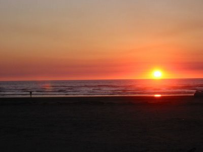
We're leaving for Ocean Shores today; the cameras and GPS are ready to go. When I get back I'll see what kind of interactive A/V presentation I can put together. Here's a photo from the last time we went:
Sunset at Ocean Shores (try doing that on any eastern coast!)
In the meantime, you can stay amused by checking out some of the nifty things people have found with Google Earth (including a very weird place in China), or take a stroll around Mars or even the moon (make sure you zoom in as far as you can go!).
If you're seriously into this kind of thing, you will also want to check out NASA's World Wind which does everything that Google Earth does and a whole lot more.


